DroneWest: Fly Through Real Cities in Your Browser
DroneWest: Fly Through Real Cities in Your Browser
What if you could fly a drone through the real streets of Kortrijk, Bruges or Ghent, without a drone, without a pilot licence and without installing anything? That is the question behind DroneWest: a drone simulator that runs entirely in the browser, on a laptop, a tablet or a Meta Quest 3 headset.
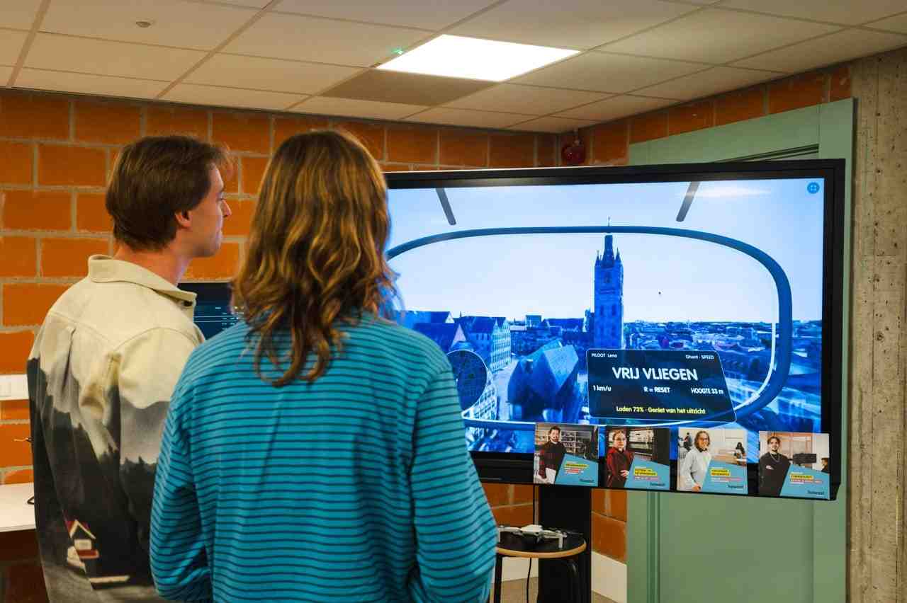
We presented it at Drone West (29 October 2026, Ostend Science Park, Bluebridge) and at the Dag van de Wetenschap (15 November 2026), where visitors took off from the Howest campus and raced through photorealistic 3D versions of Flemish cities, with a live leaderboard on a big screen next to the stand.
Main section
Quick facts
/
Presented at Drone West (29 Oct 2026) and Dag van de Wetenschap (15 Nov 2026)
/
Streamed photorealistic 3D cities via Cesium ion, 60 fps in the browser, no download
/
Drone physics with Normal and FPV (acro) flight modes
/
Real locations: Kortrijk, Bruges, Ghent and free flight worldwide
/
Fly with a real DJI RC-N1 remote via Web Serial
/
Live leaderboard on a second screen
What makes it work
DroneWest is not a game engine export or a heavy download. It is a web page. Open the link, pick a mode, and you are in the air within seconds. Under the hood, that simplicity hides a fair amount of engineering.
Real cities, streamed at 60 fps
The world is built from Google Photorealistic 3D Tiles, streamed through Cesium ion. Nothing is downloaded up front: the city loads tile by tile, getting sharper as you fly closer. Even so, the simulator runs smoothly at 60 fps in the browser, and also in VR on the Quest 3.
A few tricks make that possible:
- Route preloading. While the pilot waits at the start, virtual cameras fly along the route and fetch the tiles in advance, so the city is already sharp when you get there.
- Adaptive detail and memory. Tile detail and cache size are tuned per device. Phones and tablets get a lighter profile, because mobile browsers close tabs that use too much memory.
- Self-healing streaming. If the Wi-Fi drops for a moment, failed tile requests are retried automatically. Nobody has to reload the page, which matters at a busy event stand.
Drone physics
There are two flight modes, so first-time visitors and experienced pilots both get something out of it:
- Normal mode. A stable drone that holds its altitude and a horizon that never tilts. Easy to learn and comfortable in VR.
- FPV mode (acro / rate mode). Like a real racing drone. The sticks control rotation rates, thrust acts along the drone's own up axis (thrust-to-weight ratio of 4), and gravity and quadratic air drag do the rest. The camera is tilted 30° upwards, just like on a real FPV quad.
Collisions are computed with raycasts against the real 3D tiles. You crash into the buildings, trees and bridges exactly where they stand in the real city.
Real locations
Every route is built on real places and carefully laid out:
- Kortrijk: from the Grote Markt past the Belfry, Sint-Maartenskerk and the Budafabriek, a dive under the Noordbrug, and a finish above Howest campus The Penta. Every ring was checked with raycasts against the tiles.
- Bruges: a take-off behind the Howest Mind & Makerspace, then low over the Minnewater, the Rozenhoedkaai and the Burg to the Jan van Eyckplein. The gates were placed using the 1 m elevation model of Digitaal Vlaanderen.
- Ghent: over the Graslei and the Korenmarkt, past the Boekentoren, all the way to UZ Gent.
- Free flight: besides the Flemish cities, also Ostend (starting at the Blue Bridge), Brussels, Antwerp, Leuven, Paris, London and New York.
Game modes
- Speedrun: fly through the gates from A to B as fast as you can. Every crash adds 3 seconds.
- Heart transport (Ghent): pick up a donor heart from an ambulance and get it to UZ Gent in time. The heart is fragile, the clock is ticking, and hacked drones try to intercept you along the way. The mission is inspired by the real medical drone flights with Jan Yperman Hospital in Ieper, for which Howest Cyber3Lab tested the cybersecurity, and by our wider research on drone security.
- Free flight: explore a city of your choice, or see how far you can get in 60 seconds.
Each mode has its own leaderboard.
Flying with a real DJI remote
One of the technically most interesting parts: you can fly the simulator with a real DJI RC-N1 remote, the same controller that ships with the DJI Mini and Air drones. That remote is not a standard gamepad. It talks DJI's own DUML protocol over two serial ports. We implemented that protocol directly in the browser using Web Serial, reading the stick positions about 50 times per second. What you practise in the simulator feels exactly like flying a real drone.
The simulator also works with the Quest 3 controllers, Xbox and PlayStation controllers, a keyboard, and touch controls on phones and tablets, always using the same Mode 2 stick layout as a real drone remote.
A live leaderboard
A second screen shows who is flying in real time: timer, gates, speed and a live map with the pilot's position. An operator can queue the next pilot from that screen, so visitors never have to type their name in VR. That kept the stand running smoothly with a constant stream of new pilots.
Bottom section
What we saw at the stand
The leaderboard did exactly what we hoped. Visitors came back to improve their time and competed fiercely for first place.
But we also saw something we had not planned for. Although the goal was to be as fast as possible, many players left the route to go exploring. They circled the Belfry, dived down to the river, or searched for their own street to fly to their own house.
That says a lot about how recognisable and engaging a photorealistic digital twin of your own surroundings is. People do not just want to race through a city. They want to find themselves in it. That makes this kind of browser-based 3D a promising way to bring topics like drones, smart cities and drone security closer to a broad audience.
Technology: WebXR, three.js, 3D Tiles Renderer, Cesium ion, Google Photorealistic 3D Tiles, Web Serial (DJI DUML), OpenStreetMap, Vercel Functions, Redis.
Contributors
Researchers
/
Cesar De Greve, Creative Technologist
Want to know more about our team?
Visit the team page
Last updated on: 11/20/2026
/